


Description
Aerial Hotshots is an authorized seller of the Klau Geomatics PPK camera positioning system.
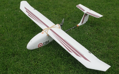
This version of the PPK module is suitable for integration into DJI’s RPA such as the Matrice 100, Matrice 600 and Inspire.
The price listed is the ‘recommended retail’ price. Contact us for a better deal.
The KlauGeomatics Direct Geo-referencing System (DGS) is a turnkey solution for all drones and sensors to achieve high accuracy mapping. It is a synergy of hardware, software and methodology to add unprecedented accuracy and efficiency to your UAV and manned aerial mapping operations. The system reduces the need for ground control points (GCP) which saves time and money while increasing accuracy and reliability. Your RPA will operate as it does now with the additional benefit of high accuracy data acquisition.
(1) How it works
Direct Geo-referencing, when done correctly, does not require GCPs. Each photo location becomes a precise control point, so your project is blanketed with hundreds of control points distributed evenly across the entire area. The system hardware logs camera events with precise carrier phase GNSS data to provide highly accurate camera positions and then utilizes post processing software to obtain precise GNSS coordinates. The software is supplied free with hardware. See the video of the processing workflow at www.geomatics.com.au.
The PPK software can process data using corrections obtained by:
- Klau Geomatics or survey base station
- CORS network
- Virtual RINEX stations
We are happy to discuss which option is best for your circumstances based on your accuracy requirements and location.
For operations which prove impractical to use a local base station or which are outside the coverages of a CORS network or Virtual RINEX station, you can utilize a satellite based positioning system.
(2) Reduce the need for GCPs
Placing GCPs can be time consuming, expensive and often take more time than the data acquisition. GCPs must be strategically distributed across the entire project area which can be a slow or near impossible task. Errors are relative to the distance from the GCP, particularly with standard non-metric cameras. Larger areas require hundreds of GCPs which can be an economic bottleneck. Smart GCPs are expensive and still require time to place and recover. Processing time is also longer with GCPs as they must be selected in the photos and the software has to do more work to determine the camera positions.
(3) RTK or PPK?
Other direct geo-referencing systems implement real time kinematic (RTK) solutions using various grades of GPS receiver. RTK works to provide accurate coordinates on the fly, with base station data transmitted to the UAV for real time processing. As a real time result is not required in this application, the limitations of RTK make it a less viable solution for direct georeferencing.
- PPK (post processed kinematic) is a better alternative to RTK for direct georeferencing, where data is logged in the UAV and processed with base station data after the flight
- PPK does not require a radio link
- It offers greater flexibility in operations, longer range from base, is more reliable, more accurate and easier to use
- Loss of correction data, particularly due to the UAV flight dynamics, signal obstructions or long distance result in loss of initialization and poor data
- You can use your own base station, CORS data or Virtual RINEX station in the vicinity
(4) Accuracy
The system logs carrier wave GNSS data and utilizes post processing techniques to produce X, Y and Z errors of +/- 50mm. These residuals can be reduced further by integrating data collection, processing and camera calibration techniques provided by the professional support team.
(5) Summary of Benefits:
- Reduces or eliminates the need for GCPs
- A plug and play solution that integrates with most cameras on most UAVs or manned aircraft
- Centimeter level camera positions, meaning the mapping and modelling you produce will have the highest possible 3D accuracy
- Professional support team
- Save time and money while producing more accurate mapping
(6) Compatible for DJI Aircraft
Direct Geo-referencing System for DJI Products
- This system is designed specifically to operate with DJI products
- Hardware and software
- Specifications:
- Multi frequency GPS (L1/L2/L2C, L5), GLONASS (L1,L2), SBAS, QZSS and L-Band enabled receiver.
- Proven technology from NovAtel
- Input voltage: 8 to 28 VDC
- Power consumption: 3 W
- Shock and vibration resistant
- Automated logging of raw GNSS with camera events
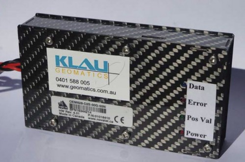
- Carbon fibre UAV enclosure: 110 x 70 x 15 mm, 200g typical total weight
- Ruggedized metal enclosure for base station or manned aircraft
- Active GNSS antenna for UAV: 51 mm height by 30 mm diameter
- Customised brackets and cables for power, camera and antenna
- Independent of UAV flight control and camera triggering system
- Plug and Play integration with any platform and DSLR camera
- User friendly PPK Processing Software supplied free with the hardware
The plug and play system is currently available for:
- Matrice 100,
- Matrice 600,
- The Inspire.
- All other DJI products (Phantom 3, 4, M200, any DJI camera) can be modified to integrate the system. Modification requires the UAV to be sent to the workshop. It takes 2 to 4 weeks, depending if the mounting kit has already been designed and costs around $600.
(7) Compatible Cameras
Camera signal capture is achieved from most cameras:
- DJI cameras, X3 and X5
- Phase One and Hasselblad
- Any DSLR camera
- Light cameras with a flash hotshoe or output
- Light cameras with no flash output (requires camera modification)
- Micasense RedEdge multispectral
- Other cameras such as thermal, multi-spectral, LiDAR
(8) Payment and Delivery
- 100% payment is required prior to customized system build and delivery.
- Delivery of the system will be within 3-4 weeks of receiving a purchase order and payment.
- You may be required to provide your camera during the integration process.
- We will offer support if required in all aspects of the system: installation, operation, DGS processing and photogrammetry
Reviews
There are no reviews yet.