Gold Coast Aerial Photography
Gold Coast Aerial Photography is conducted from our aviation base at Archerfield Airport. As our proces are fixed, Gold Coast clients pay the same as Brisbane clients. A large portion of our Gold Coast aerial photography assignments are around the Greater Gold Coast. These operations can be challenging at times due to the proximity to Gold Coast Airport and Airspace restrictions. As we are very experienced the job is always completed and that Hero Shot is captured. We are not just aerial photographers and offer a variety of photography services to meet our clients needs.
Our services for the Gold Coast include;
- Gold Coast Aerial Photography,
- Gold Coast Commercial Photography,
- Gold Coast Architectural Photography
- Gold Coast Construction Photography
- Gold Coast Elevated (Mast) Photography
- Gold Coast Drone Photography
- Gold Coast Drone Survey
- Gold Coast Drone Asset Inspection
- Gold Coast Drone Courses
Gold Coast Aerial Photography – Airspace
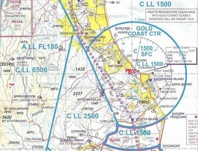
Conducting Gold Coast aerial photography assignments is not as challenging to Brisbane where most of the Greater Brisbane suburbs are in airspace that is classified as Controlled Airspace and is under the control Brisbane Air Traffic Control.(ATC)
For gold coast aerial photography assignments on the Gold Coast we can generally perform our aerial photography operations north of the Q1 without any ATC clearances. However, flying south of the Q1 will generally require an ATC clearance.
The below Gold Coast Aviation Map, a VTC, shows the Gold Coast airspace. The Blue circles represent areas controlled by Gold Coast Air Traffic Control at varying heights. I have marked the map with YBCG which is the code for Gold Coast airport and marks its location.
Gold Coast Aerial Photography Image Library
Aerial Hotshots has a image library that contains a selection of ‘working’ Gold Coast aerial photography images captured to meet sales, marketing and advertising campaigns and as such are ideal for real estate agents, land developers, construction companies and the like. Click on this linkto view some Gold Coast Aerial Photography examples from our image library.
Gold Coast – General Information
The Gold Coast Urban Structure is great for Gold Coast aerial photography. Gold Coast City is situated in the southeast corner of Queensland, to the south of Brisbane, the state capital. It is separated from Logan City, a suburban area of Brisbane by the Albert River. There the Gold Coast City stretches from Beenleigh and Russell Island to the border with New South Wales approximately 56 km (35 mi) south, and extends west to the foothills of the Great Dividing Range in World Hertitage listed Lamington National Park.
The southernmost town of Gold Coast City is Coolangatta which includes Point Dangerand its lighthouse. Coolangatta is a twin city with Tweed Headslocated directly across the border. This is the most easterly point on the Queensland mainland (Point Lookout on the offshore island of North Stradbrokeis slightly further east). From Coolangatta, approximately forty kilometres of holiday resorts and surfing beaches stretch north to the suburb of Main Beach, and then further on Stradbroke Island. The suburbs of Southport and Surffers Paradise form Gold Coast’s commercial centre. The major river in the area is the Nerang River. Much of the land between the coastal strip and the hinterland was once wetlands drained by this river, but the swamps have been converted into man-made waterways (over 260 km, or over 9 times that of Venice, Italy) and artificial islands covered in upmarket homes. The heavily developed coastal strip sits on a narrow barrier sandbar between these waterways and the sea.
To the west, the city is bordered by a part of the Great Dividing Range commonly referred to as the Gold Coast Hinterland. A 206 km² (80 miles²) section of the mountain range is protected by Lamington National Parkand has been listed as a World Heritage area in recognition of its “outstanding geological features displayed around shield volcanic craters and the high number of rare and threatened rainforest species.” The area is popular among Bushwakers and day-trippers
Gold Coast Climate – Great for Gold Coast Aerial Photography
The Gold Coast Climate produces beautiful days that are ideal for Gold Coast Aerial Photography. Gold Coast experiences a humid subtropical climate, with mild winters and warm and humid summers. The city experiences substantial summer precipitation mostly concentrated in thunderstorms and heavy showers with rain events occasionally lasting up to a few weeks at time giving residents “the Summer blues”, while winter is beautifully sunny, warm, and fairly dry. In fact, it is this pleasant winter weather that both the city and the surrounding coastal region, the Sunshine Coast, is named after and internationally renowned for.
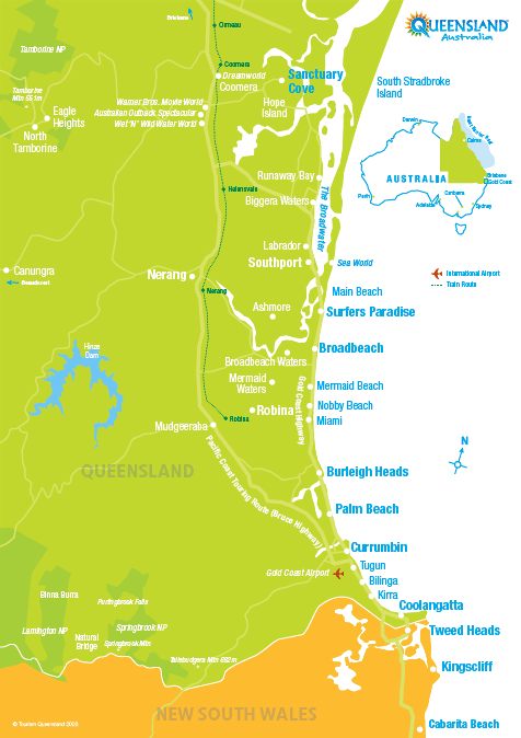
A Map of the Gold Coast