Premium Survey Drone Service
Due to a change in strategic direction, as of the 1st of January 2018, Aerial Hotshots will no longer offer drone survey services. Aerial Hotshots uses the AscTec Falcon 8 and the Event38 E384 for Drone Survey assignments. These Drones are professional grade survey quality drones that are proven and tested in the survey industry. They are far superior in flight software, payload options, data acquisition capability, has precision software and the end product is well advanced. These Drones capture accurate georeferenced imagery that is essential for survey operations and both are fitted with next generation sensors that provide significantly higher precision in the measurement of the drones speed, attitude and position and therefore more reliable.
Due to a change in strategic direction, as of the 1st of January 2018, Aerial Hotshots will no longer offer drone survey services.
“A Smart, Safe, Efficient and Cost Effective Alternative to Traditional Surveying”
Our Survey Drone Premium Service
The ‘premium’ drone survey service is suited to clients where accuracy is essential to their assignment in both data capture and data processing.
Benefits of this service include:
- Survey drones are fitted with a Post Processed Kinematic (PPK) camera positioning system that:
- Produces high accuracy GNSS camera positions,
- Increases the accuracy in photogrammetric mapping,
- Reduces ground control requirements (efficient and cost effective).
- Capture of high resolution imagery,
- Data processing by a Photogrammetrist.
We also use a variety of other survey support tools including a survey grade GPS logger, a survey grade base station and photogrammetry software.
Multirotor
The AscTec Falcon 8 went into serial production in 2009 and is since used globally for professional applications. For your projects the octocopter offers unprecedented precision and safety with the reliable AscTec High-Performance GPS and the new control unit AscTec Trinity. Our AscTec Falcon 8, fitted with PPK technology, will capture accurate georeferenced imagery that is essential for survey operations.
It is fitted with next generation sensors that provide significantly higher precision in the measurement of the drones speed, attitude and position and therefore more reliable. It has triple redundant IMU for maximum safety, three inertial measurement units to ensure quick and reliable data fusion, data verification. The camera gimbal has active stabilisation and vibration dampening.
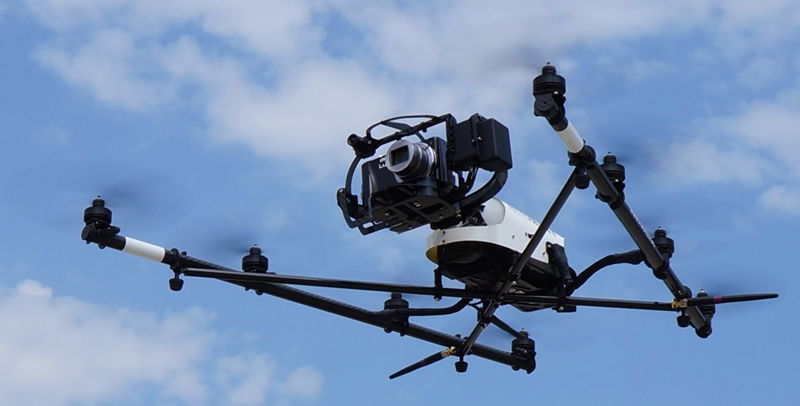
- Standard: Sony A7 Camera which produces 36mp georeference imagery.
- Inspection Package: Infrared imagery and conventional imagery recorded simultaneously
- Video Package: 10x zoom that is ideal to zoom in a subject whilst inspecting infrastructure
- Infrared: FLIR Infrared Camera with AscTec IT Raw Data Logger.
Fixed Wing
The Event38 E384, fitted with PPK technology, will capture accurate georeferenced imagery that is essential for survey operations.
Its customized mission planner package automatically plans flight lines and overlap based on the sensor and desired ground resolution.
For repeat jobs, we can save a mission and retrieve it with a few clicks. The Intellishoot smart image capture system ties the camera in to the autopilot and GPS for precise control.
It takes pictures at the planned overlap rate, and saves the GPS coordinate for each image automatically.
Images and geotags are saved in industry standard formats.
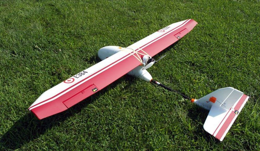
For the standard survey work, the drone is fitted with a Sony QX1, that captures 20mp imagery.
Data Processing and Inspection Tool
Photogrammetrist
Aerial Hotshots outsources our data processing to the photogrammetry division of a large and experienced survey firm to ensure our clients are provided with accurate data.
Our advice is simple, employ a drone business offering professional survey services. There are plenty of unqualified providers out there.
Inspection Tool
The below video demonstrates the capabilities of Propeller, which is an Industry Leading Software tool for Drone Mapping, Surveys and Inspections. It is accessible to anyone with a web browser and internet connection, Propeller Platform simplifies processing and visualization of drone data. With a few clicks, users can create, measure, analyse and share detailed surveys, high resolution maps or asset inspections.
Benefits, Capabilities, Outputs, Services
For information on the benefits, capabilities, data outputs and our services please click here.