Event38 – Survey & Mapping Drone Distributor
Aerial Hotshots is a authorised reseller and distributor for Event38. Event38 designs and manufactures drones (RPA/UAVS), specialised optical sensors, and a Drone Data Management System for Construction, Environmental Conservation, Mining, Surveying and Precision Agriculture.
Mapping and Surveying Drones
Event 38 builds drones, sensors and post-processing software for creating high resolution, low cost maps on demand. Event38 services customers in surveying, agriculture, aggregates and research. With Event38’s diverse experience and product line, and as a reseller, we can recommend the appropriate equipment to meet your requirements and budget. Support engineers will be able to assist you with every step from setting up and flying a drone to integrating the data into your existing workflow.
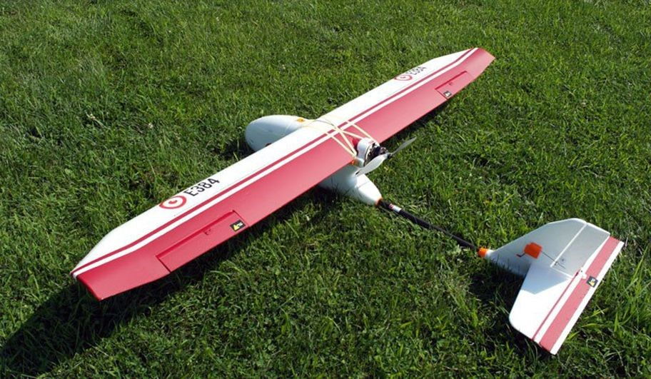
Event38 – E384 – Fixed Wing UAV
Event38 – E384
The E384 is an autonomous platform made specifically for collecting the data needed to produce georeferenced ortho-mosaics, digital elevation models (DEMs), and more. Its customised Mission Planner package automatically plans flight lines and overlap based on the sensor and desired ground resolution. For repeat jobs, you can save a mission and retrieve it with a few clicks. The Intellishoot smart image capture system ties the camera in to the autopilot and GPS for precise control. It takes pictures at the planned overlap rate, and saves the GPS coordinate for each image automatically. Images and geotags are saved in industry standard formats.
• EPO foam can flex/bend without breaking. EPO foam technology allows structural flexibility to dissipate energy in tight turns and hard landings. Closed cell foam absorbs damage from obstacles rather than cracking or breaking on impact.
• Dents and dings can be repaired by dipping the affected area in boiling water, forcing the beads to expand back to their original shape
• EPO Foam is superior to fiberglass or carbon fiber construction because it is easily repaired with readily available tools like glue and tape
• If a really hard crash were ever to happen, we can remove all the expensive electronics, sell you a new inexpensive replacement E384 airframe, and you essentially have a brand new drone.
• Main Camera
• Auxiliary Cameras
• Extra Flight Batteries
• Replacement Frame
• Carrying Case
• Post Processing Software Packages
• 3D Robotics Pixhawk Flight Controller
• Flight Planning and Control Software for Autonomous Flight (Includes GPS and Flight Data Log)
• Professional Handheld Remote Controller
• 1km Ground Station Monitoring and Command Radio (Upgrade to 10km Available)
• 1 Flight Battery and Rapid Charger – 4 Cell, 8.0 Ah LiPo
• Online Operations Manual
• Tutorial Videos
• Printable Offline Operations Manual
• Pre-Field / Pre-Flight Checklists
The major differences in these cameras are as follows.
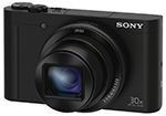
• Sony WX500 – 18MP Resolution
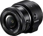
• Sony QX1 – 20.1MP Resolution, Includes 16 mm pancake lens, external power supply, and landscape shooting for increased efficiency.
• Customized Canon Powershot S110 with infrared filters specifically designed to measure NDVI. Using ratios of visible light to infrared light,
we can calculate NDVI, which allows for the detection of crop health.
Other camera options are available for specialty applications, please contact us for more information.
• MicaSense RedEdge
• FLIR Vue Pro
Highlights include:
• We warrant that the products we ship to you are free from defects in material and workmanship when used normally and in accordance with operating instructions.
• This warranty extends to the original purchaser for a period of 120 days or first flight whichever comes first.
• During the limited warranty period, Event 38 or authorized service representative will repair or replace a defective product at Event 38′s option.
An Extended Warranty that protects your E384 for one year is available for purchase. Click here for complete information. Highlights include:
• For a period of one year, we warrant that products and accessories provided by Event 38 are free from defects in material and workmanship when used normally and in accordance with operating instructions.
• Plan covers physical damage, including impact damage from accidental crashes, but does not cover lost or stolen items or a few other items.
• Plan covers full parts and labor and shipping costs on all hardware failures.
• Dimensions: 190cm Wingspan, 130cm Length (75 x 51 inches)
• Wings and body disassemble for easy transport
• Weight: 2.5kg (5.6 lbs)
• Endurance: 100 minutes flight time
• Cruise Speed: 13m/s (29 mph)
• Range: 70km (44 miles)
• Map up to 1,000 geo-referenced acres per flight at 5.0cm/pixel resolution (400 Ha)
• Max Payload: 1kg (2.2 lbs)
• Automatic lens protection for landing
• Complete mission planning and operations software
• For your Windows 7, 8 or 10 laptop (not included)
• Autonomous flight, Return-to-launch, Automated pre-flight checklists, much more
• Complete operating instructions online and downloadable
• Operating Conditions
• MSL Ceiling: 3,960 meters, (13,000 ft), – auto take-off tested to 3,100 meters, (10,000 ft)
• Max sustained wind speed: 10 m/sec, (22 mph) for autonomous operation
• Telemetry Range: 1km from ground station to aircraft, (0.6 mi)
• 10 km+ with optional long range radios, (6.2 mi)
E384 Auto Take-off and Landing Capability
The E384 offers a auto launch capability. In Mission planner, the auto launch function is enabled and the take-off altitude and pitch angle is set. The launch is performed by two people: the pilot and the laucher. The launcher uses a two handed throw technique to launch the E384 at a 15 degree angle. Once the E384 senses it is moving at 2m/s the motor starts and it climbs to the preset take-off altitude. Once at the altitude, the E384 commences it preset flight plan.
The E384 auto land function is not as accurate as the E386 as the E386 has a laser rangefinder and reverse thrust capability. The E384 auto land capability requires an obstacle free approach and a landing area of 150mx 30m compared to E386 of 65m x 35m.
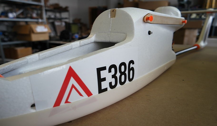
Event38 – E386 – Fixed Wing UAV
Event38 – E386
The E386 has been proven through thousands of hours of flight from hot and humid jungles to freezing mountains above 13,000 feet. It can fly 850 acres in 85 minutes at 5cm resolution completely autonomously. The E386 integrates seamlessly with Event38 Drone Data Management System to create sophisticated analytics from your flight data. The E386/DDMS combination gives businesses accurate and timely solutions to better run their organizations. This package is customizable depending on your application. Each E386 is flight tested, and a dedicated support engineer is available to help you get set up and flying.
• EPO foam can flex/bend without breaking. EPO foam technology allows structural flexibility to dissipate energy in tight turns and hard landings. Closed cell foam absorbs damage from obstacles rather than cracking or breaking on impact.
• Dents and dings can be repaired by dipping the affected area in boiling water, forcing the beads to expand back to their original shape
• EPO Foam is superior to fiberglass or carbon fiber construction because it is easily repaired with readily available tools like glue and tape
• If a really hard crash were ever to happen, we can remove all the expensive electronics, sell you a new inexpensive replacement airframe, and you essentially have a brand new drone.
• 3D Robotics Pixhawk Flight Controller
• 1 Year Drone Data Management System™ Professional Tier
• Flight Planning and Control Software for Autonomous Flight
• Handheld Remote Controller
• 10km Ground Station Monitoring and Command Radio
• 1 Flight Battery and Rapid Charger – 4 Cell, 8.0 Ah LiPo
• Carry Case
• Online Operations Manual
• Tutorial Videos
The major differences in these cameras are as follows.
• Sony WX500 – 18MP Resolution
• Sony QX1 – 20.1MP Resolution, Includes 16 mm pancake lens, external power supply, and landscape shooting for increased mapping efficiency.
• Customized Canon Powershot S110 with infrared filters specifically designed to measure NDVI. Using ratios of visible light to infrared light, we can calculate NDVI, which allows for the detection of crop health.
• Thermal and multispectral sensors are available upon request
Highlights include:
• We warrant that the products we ship to you are free from defects in material and workmanship when used normally and in accordance with operating instructions.
• This warranty extends to the original purchaser for a period of 120 days or first flight whichever comes first.
• During the limited warranty period, Event 38 or authorized service representative will repair or replace a defective product at Event 38′s option.
An Extended Warranty that protects your E384 for one year is available for purchase. Click here for complete information. Highlights include:
• For a period of one year, we warrant that products and accessories provided by Event 38 are free from defects in material and workmanship when used normally and in accordance with operating instructions.
• Plan covers physical damage, including impact damage from accidental crashes, but does not cover lost or stolen items or a few other items.
• Plan covers full parts and labor and shipping costs on all hardware failures.
• Dimensions: 190cm Wingspan, 130cm Length (75 x 51 inches)
• Wings and body disassemble for easy transport
• Required Area for Automatic Steep Dive Landings: 25x65m (27×71 yards)
• Steep Dive Gradient: 35 – 60%
• Weight: 2.75kg (6 lbs)
• Endurance: 75 minutes flight time
• Cruise Speed: 13m/s (29 mph)
• Range: 58km (36 miles)
• Map up to 700 geo-referenced acres per flight at 5.0cm/pixel resolution (280 Ha)
• Max Payload: 500g (1.1 lbs)
• Automatic lens protection for landing
• Complete mission planning and operations software
• For your Windows 7, 8 or 10 laptop (not included)
• Autonomous flight, Return-to-launch, Automated pre-flight checklists, much more
• Operating Conditions
• MSL Ceiling: 3,960 meters, (13,000 ft), – auto take-off tested to 3,100 meters, (10,000 ft)
• Max sustained wind speed: 10 m/sec, (22 mph) for autonomous operation
• Telemetry Range: 10 km+ with long range radios (6.2 mi)
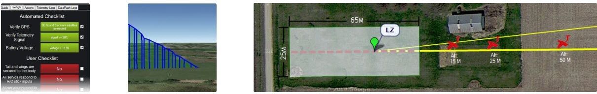
E386 Complete Autonomy Launch-to-Landing
The E386 offers launch and recovery capability unprecedented in its class, capable of fully autonomous takeoff, flight, and landing. Long endurance aircraft often require a larger space for recovery. The E386 overcomes this limitation by diving steeply toward the recovery zone and using reverse throttle to bring the aircraft quickly to a stop. An onboard laser rangefinder ensures an accurate flare and soft touchdown. If you have a 25 by 65 meter (27 by 71 yards) area free of major obstacles, you can land the E386 by simply entering the beginning and end of the clear area into Mission Planner.
Event38 – IRIS+ Precision Mapping Package
Event38 – IRIS+ Precision Mapping Package
The Iris+ Precision Mapping Drone is a premiere, easy-to-use multirotor mapping platform. This kit comes with everything needed to fly, including RC transmitter, telemetry modems, and a battery. All you’ll need to provide is your own laptop. All components are configured, calibrated and flight tested prior to leaving the factory.
• Manual and Autonomous Flight Support
• Carries Standard RGB sony WX500 as well as NDVI Converted Canon S110
• Telemetry Modules Support Mission Planner Ground Station Software
• Allows complete UAS control from a laptop
• Battery Voltage and Current Sensor
• Manual and Autonomous Flight Support
• Carries Standard RGB sony WX500 as well as NDVI Converted Canon S110
• Telemetry Modules Support Mission Planner Ground Station Software
• Allows complete UAS control from a laptop
• Battery Voltage and Current Sensor
• Preconfigured 32-bit Pixhawk Autopilot
• Includes GPS, IMU, Pressure Sensor and Flight Data Log
• Autonomous, Waypoint-Guided Flight Capable
• Turnigy 9X Transmitter for Manual Override Capability
• Rechargeable Battery Set for Turnigy 9X
• 5100mAh 3S Flight Battery Pack
• LiPo Battery Charger
• Your Choice of Telemetry Frequency (433mHz or 915mHz)
• Anti-Vibration Camera Mount
• Intellshoot (Intelligent Camera Control)
• Your camera choice of Sony WX500 or NDVI Converted S110 (or both!)
The major differences in these cameras are as follows.
• Sony WX500 – 18MP Resolution
• Sony QX1 – 20.1MP Resolution, Includes 16 mm pancake lens, external power supply, and landscape shooting for increased efficiency.
• Customized Canon Powershot S110 with infrared filters specifically designed to measure NDVI. Using ratios of visible light to infrared light,
we can calculate NDVI, which allows for the detection of crop health.
Other camera options are available for specialty applications, please contact us for more information.
• MicaSense RedEdge
• FLIR Vue Pro
• Standard Weight (fully assembled with Canon S120): 1.6 kg
• Standard Weight Flight Time: 13:00 minutes
• Battery: 316g (5100mAh 3S)
• 5m/s flight speed
• 2500m altitude ceiling
• 1 km telemetry range
• 18 MP camera resolution
• Coverage/resolution
• 50 acres @ 5cm/pixel
• 40 acres @ 3.6cm/pixel
• 16 acres @ 1.5 cm/pixel
An Extended Warranty that protects your IRIS+ for one year is available for purchase. Click here for more information.
Event38 Systems – Made for Mapping
The Event38 aircraft are autonomous platforms made specifically for collecting the data needed to produce georeferenced ortho-mosaics, digital elevation models (DEMs), and more. The entire workflow has been streamlined for this purpose from mission planning to post-processing. Our customized Mission Planner package automatically plans flight lines and overlap based on the sensor and desired ground resolution. For repeat jobs, you can save a mission and retrieve it with a few clicks. The Intellishoot smart image capture system ties the camera in to the autopilot and GPS for precise control. It takes pictures at the planned overlap rate, and saves the GPS coordinate for each image automatically. When the mission is over, it closes the camera hatch just before touch-down to protect the camera lens from dirt and debris. Images and geotags are saved in industry standard formats. They can be used with our Drone Data Management System or other post-processing software.
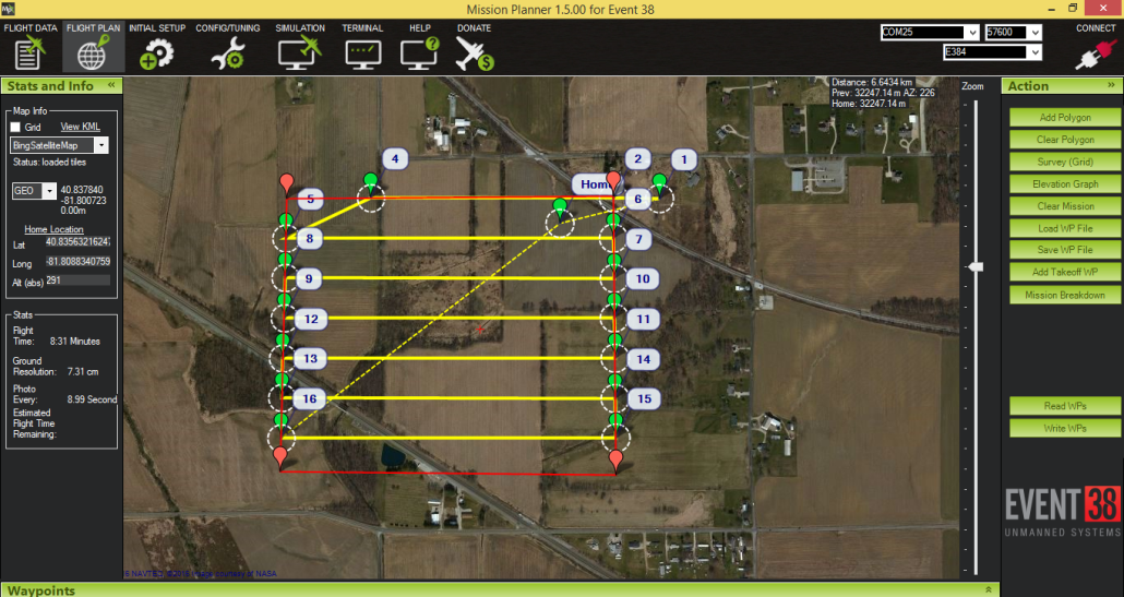
Mission Planner
Mission Planner is an easy to use planning and flight control system. It connects wirelessly to your aircraft and allows you to see flight telemetry and change mission parameters in real time. Key Mission Planner features include:
- Quickly plan, save and upload autonomous mission plans into your E384 with a simple point-and-click interface
- An automated preflight checklist
- Real time flight data: altitude, speed, direction, battery level, and see its location on a moving map
- Automatically recording logs of every flight for record keeping and compliance
Payloads & Sensors
Survey and Mapping Sensors
Sony WX500 ( Portrait)
Sony Qx1 (Landscape)
Special Purpose Sensors
Event38 modify this Canon to block red light and record instead near infrared light above 700nm wavelength.
Drone Comparison
| IRIS+ PRECISION MAPPING DRONE | E384 | E386 | |
|---|---|---|---|
| Flight Time | 12 minutes |
|
85 minutes (WX500) |
| Mapping coverage (5cm/pixel, 60/60 overlap/sidelap) | 50 acres | 1000 acres | 850 acres |
| Infrastructure Requirement | Takeoff: 3m Cleared Circle
Landing: 3m Cleared Circle |
Takeoff: None
Auto Landing: 150x30m cleared space Pilot Landing: 40x15m cleared space |
Takeoff: None
Landing: 65x35m Cleared Space |
| Sensor Options | WX500, NDVI | WX500, QX1, NDVI, Sequoia, FLIR,MicaSense RedEdge | WX500, QX1, NDVI, Sequoia, FLIR, MicaSense RedEdge |
| Special Features | Accessing Tight Worksites | High Productivity | Autonomous Short Field Landing |